
This exhibit was designed to travel and is available on loan to schools, libraries, community groups, and smaller rural museums/galleries around southern Alberta. To learn more, read the full exhibit details.
co-curated by Ninna Piiksii (Mike Bruised Head), Itsinohtss piyaki (Rebecca Many Grey Horses), and Akaiksims’staki (Bobbie Fox)
Since time immemorial the people of the Blackfoot Nations have called southern Alberta home. Their traditional territory stretches north to the North Saskatchewan River, south to the Yellowstone River, west to the Rocky Mountains, and east to the Cypress Hills. They travelled throughout their land guided by the seasons, taking only what was needed from the land and its animals but never to excess and with nothing left to waste. The Nitsitapii have a spiritual connection to the land and through this connection are stewards of this earth.
Many sites located throughout this territory have meaning which can be categorized as Spirit-created, Nature-created, or Human-created. Spirit-created sites are places created and touched by Napi. Napi is the name of the Creator for the Nitsitapii. Nature-created sites are places or geographic features that came into being through natural geologic forces. Human-created sites are places that were created by the Nitsitapi through the alteration of the natural landscape. We are focusing on ten such sites.
Land Acknowledgement of Nitstapiisksahkoo
The City of Lethbridge and the Galt Museum & Archives are proud to acknowledge that Sikoohkotoki (Lethbridge) is located in the heart of Siksikaisitapi, which is the traditional territory of the Blackfoot People from Kainai, Piikani, Siksika and Amskapi Pikuna.
Engaging with Blackfoot and other Indigenous Peoples who live, study, work and play in our community in respectful and meaningful ways, is an opportunity to hear new and diverse perspectives, and importantly, to understand historical and contemporary barriers and opportunities. Some of the stories shared by Indigenous Peoples may at times be challenging or difficult to hear. But they are important nonetheless.
Acknowledging territory and seeking Nitsitapii perspectives is an opportunity to come together in shared understanding, which is the framework upon which we build a stronger community together.
Please Note:
The sites discussed in this exhibit are from a Blackfoot perspective. They are considered sacred and spiritual places by the Nitsitapii from time immemorial. Many are currently used by the Blackfoot Nations for spiritual and ceremonial purposes. We ask that if you visit these places, please be considerate and respectful of the cultural importance of these places. If you see cairns of stones or gifts left from a ceremony or prayer, please leave the area untouched. An acceptable practice is offering tobacco at these sites which is proper protocol.
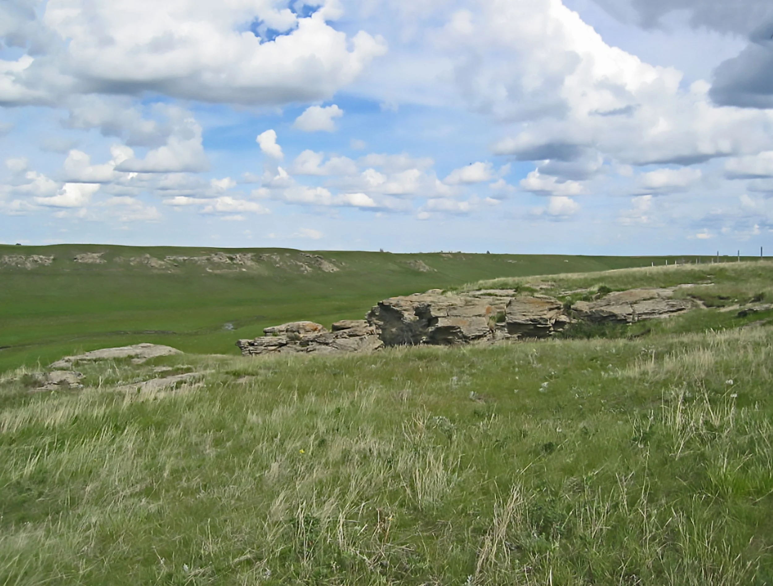
Mokowaansistsi (Belly Buttes)
I will share stories from Blackfoot Elders who were excellent orators and storytellers. These stories are about Siksikaitsitapisahko, Blackfoot lands. The buttes and their relationship with the Belly River make them a combination of a spiritual and natural formation. The Kainai Elders had these interpretations and stories from those before them. I have also seen a picture of the buttes that looks like a man lying face up. I'm combining all three thoughts to give a complete picture of the Belly Buttes, northeast of Standoff.
There are several versions of the Belly Buttes, Mokowaansistsi. One is a spiritual story. Napi was chasing a gigantic, spiritual buffalo and wounded it. As the buffalo ran, parts of the body were falling out. One part was the belly that fell on the ridges of these hills and coulees. The rest fell across the landscape between here and Nose Hill in Calgary.
Another story told by the Kainai Elders is if you stand on the north side of the buttes close to the Belly River and look back at the first butte. It has an outline of a person lying flat facing up to the sky.
The next connection with the Belly Buttes is its geological one with the Belly River. The Belly River’s north and south fork start in Montana, at one of the glacier lakes in the area now called Glacier National Park. It flows past Standoff and the Blood Reserve. The two sets of buttes that form the Belly Buttes are located on the Blood Reserve. They are considered sacred, precious, and very historical. The Kainai and Siksikaitsitapi (the Blackfoot tribes) respect this site. Right at the western slope on the grassy plains, we have our summer ceremonies that are still going on today.
The Chiefs, and especially Red Crow, Mi’kai’sto, did not like being put on the reserve east of Cluny, towards the eastern part of Alberta away from the Buttes. They spoke up during treaty negotiations in 1877 and said “No!” They didn't openly agree to the reservation, they wanted to see Nínaiistáko (Chief Mountain) and the Belly Buttes.
—Ninna Piiksii


To hear the story of this site in Blackfoot, please listen.
These stories are transferred from generation to generation since time immemorial. You are listening to a shorter version of a much larger story. If you would like to expand your knowledge of this site, please see a Blackfoot Elder.
Soyioh’powah’ko (Blackfoot Crossing)
I’ll share some history of the Blackfoot Crossing and why it’s a special place. Blackfoot Crossing is on the present Blackfoot Reserve, in the Cluny and Gleichen area, and the Bow River flows through the location. In the Bow River, there’s an underwater ridge, Soyioh’powah’ko, or an island that is covered by water. Prior to 1877, it had the name, Soyioh’powah’ko. It was a crossing used from time immemorial. The Blackfoot Crossing area, Soyioh’powah’ko, has been a camping area for thousands of years. The Blackfoot people, Siksikaitsitapi, knew of this place.
Prior to being known as the 1877 treaty negotiating area, during the dog days, the pedestrian days, there were already winter and summer camps there by Siksikaitsitapi, especially the North Blackfoot. Blackfoot Crossing was where the Siksikaitsitapi, the Blackfoot people, would cross the Bow River on foot. Children, Elders, and leaders, especially the scouts of numerous bands from Siksika, Kainai, Piikani, and Amskapi Pikuna. They knew the landscape of where to cross, camp, hunt, and harvest medicines.
Today everybody recognizes that that’s where the Blackfoot Treaty was negotiated. The four nations had between 40 and 50 bands present. We were placed on four reservations when we should have had forty reservations or more, so that is the story of Blackfoot Crossing.
The energy of Soyioh’powah’ko, ridge underwater or island underwater, has been known long before Europeans ever stepped into traditional Blackfoot Territory. It’s a magnificent place today. Please visit the area and the Blackfoot Historical Center and then you’ll begin to understand the importance of the site to the Blackfoot Treaty.
—Ninna Piiksii


To hear the story of this site in Blackfoot, please listen.
These stories are transferred from generation to generation since time immemorial. You are listening to a shorter version of a much larger story. If you would like to expand your knowledge of this site, please see a Blackfoot Elder.
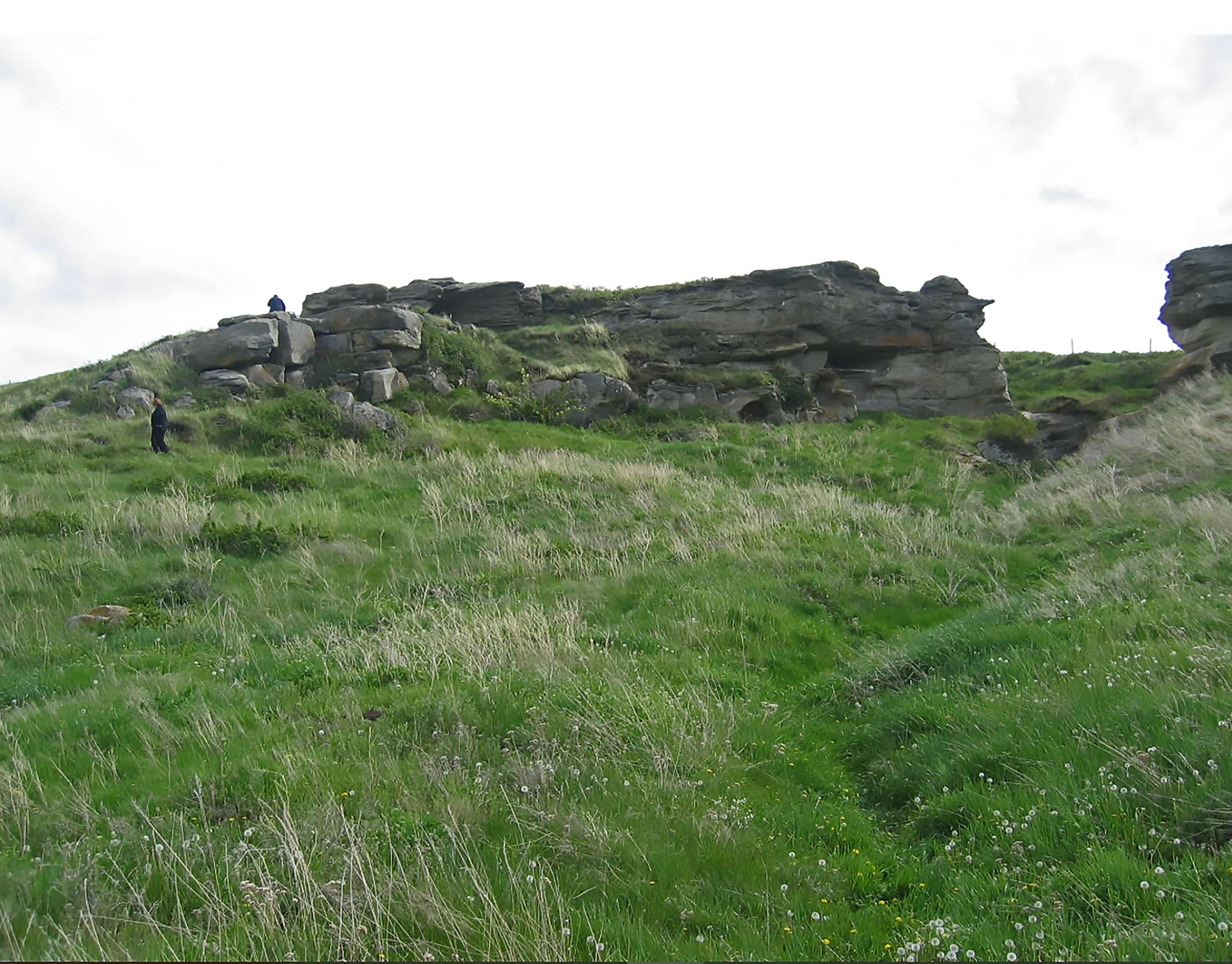
Ákáómma’pisi/Umaapi/Onoka-Katzi (Sundial Butte)
I’m going to share Sundial Butte from a Blackfoot perspective. There are several stories about Sundial Butte, which is located north of Lethbridge. These rock cairns, we call them, ákáómma’pisi or umaapi, are a gathering of rocks, with circles—not necessarily tipi rings. Sundial Butte has four rings and is estimated to be over 2,000 years old. Many of these rock mounds have a deep and highly significant purpose. It is not known why the first people—our people from way back then—brought rocks, especially the great big rocks, to these areas, physically or spiritually. Whether a significant and powerful experience happened there or receiving directions from spirits to make a vow because of a dream and are directed: “You have to build something like this.”
In the Blackfoot world, the number four is significant. When you get to the fourth time of anything, then you’ve entered a very spiritual energy setting. The first ring starts it, and all the way to the fourth ring. Sundial Butte is quite interesting. The entranceway is facing south rather than east. The Elders say that this ring was to honour Napi and that’s where the spirit entrance is. These are vortex places. The story is that this is a spiritual place—a place of offering, prayer, and meditation. For thousands of years, the Siksikaitsitapi bands travelled, before the horse, through here putting offerings of tobacco, meat, or hide.
These kinds of rock mounds are to be there forever, never to be dismantled. In Nitstapiisksahkoo, Blackfoot lands, please respect these sites; do not vandalize or dismantle them. If you want to visit, offer tobacco there. Show your respect. I guarantee you will be blessed when you respect these ancient sites.
—Ninna Piiksii


To hear the story of this site in Blackfoot, please listen.
These stories are transferred from generation to generation since time immemorial. You are listening to a shorter version of a much larger story. If you would like to expand your knowledge of this site, please see a Blackfoot Elder.
Napi ootsisti’ kowanhpi (Napi’s Playground)
This landscape story is about Napi’s Playground, on the upstream of Oldman River, Naapihtaa. Where Napi, the legendary Blackfoot figure, had a deal with some animals and humans. He wanted to play hand games; he challenged them. He told the opposition: “If you win, things will go your way and if I win, you have to abide by what I want.” The challengers—some were people from west of the mountains and some were animals—agreed to a game of hand games. The hand games started in the mountains. It went on for a long time, the sticks going back and forth. Napi kept trying to do tricks, but the opposition players wouldn’t allow it. Napi eventually won and the people had to go back west. The Oldman River headwaters were where Napi and the Blackfoot people enjoyed the mountains.
A lot of hand game songs came from that game which are still used today. So that is one version I heard from the Elders, both Kainai and Piikani. There’s a lesson to learn from Napi and all these Napi stories: to respect what he made and what the Creator made. That is a short version of Napi’s Playground.
—Ninna Piiksii


To hear the story of this site in Blackfoot, please listen.
These stories are transferred from generation to generation since time immemorial. You are listening to a shorter version of a much larger story. If you would like to expand your knowledge of this site, please see a Blackfoot Elder.
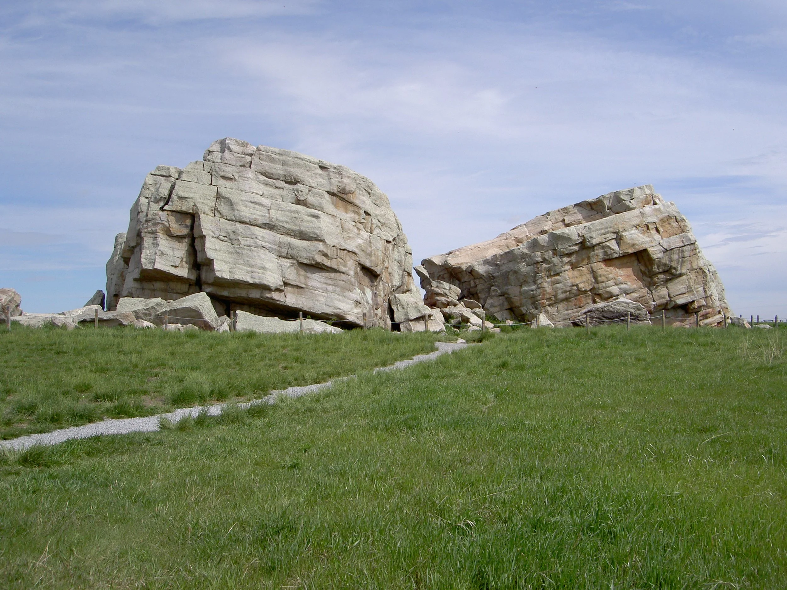
Ohkohtoki (Okotoks Erratics)
This brief story is about Ohkohtoks the rock, which is located on the outskirts of the town that bears its name. The story begins a long time ago when Napi—the Blackfoot Creator—was walking along in his buffalo robe. He met up with the rock spirit, which took the physical form of a rock. Napi became friends with Ohkohtok the rock and gifted him with his buffalo robe—whether it was due to the rock being cold, or just as a gift to become friends. The rock was very happy to become friends with Napi and to receive a robe as a gift from him. They were friends for a long time.
One day, Napi changed his mind and took back the buffalo robe. This upset Ohkohtok the rock, and he told Napi, “You can’t do that. Once you give something as a gift you cannot take back.” But Napi, being a trickster, took the buffalo robe and started running away. Rock chased him, rolling through the mountains creating gorges, divides, and coulees. Rock was angry because he wanted the robe back. As Rock was catching up to Napi to get his robe back and roll over him, two birds came flying along to help Napi. He called out to Piiksii (birds), and these two birds saw Napi, “Aww jeez Napi, we gotta help him!” They flew close to the swiftly rolling Ohkohtoki and started quickly pecking at the Rock splitting him.
Napi was saved and escaped. He thanked the birds, who told him, “You know, Ohkohtoki was right. You don’t take things back when you give them as a gift.” Napi had learned a lesson from that.
This erratic is south of present-day Mohkinitsi (Calgary). The legend behind it is quite fascinating because that erratic is almost in the middle of the prairie foothills and all by itself and the story suits it. This is the common Blackfoot story that I have heard since I was a child, but I also heard an older version which you can hear when you go visit the Elders that know the older story.
—Ninna Piiksii


To hear the story of this site in Blackfoot, please listen.
These stories are transferred from generation to generation since time immemorial. You are listening to a shorter version of a much larger story. If you would like to expand your knowledge of this site, please see a Blackfoot Elder.
Iitopahmaapi/Saakiimaapi/Maisstooinastáko (Vimy Peak/Crow Chief Mountain)
This story is about the mountain with the recent European name of Vimy Ridge in Paahtómahksikimi (Waterton) on the Upper Waterton Lake. Prior to the First World War, the Blackfoot called it, One Who Sits Across The Water, Saakiimaapi.
All the mountains in Paahtómahksikimi prior to European arrival had their own spiritual significance, and some even had their own songs in Blackfoot.
There are trails on the mountain because of vision quests and Blackfoot prayer sites. Blackfoot people have been here for thousands of years. The Blackfoot people are not only plains people but also mountain people. Blackfoot people can adjust to the landscape of what the Creator gave us. So that is the story of Saakiimaapi which is a sacred mountain.
Another related story to Vimy Ridge is about Joe Crow Chief, a Kainai veteran of the First World War. According to the story Joe Crow Chief and a fellow officer were able to climb Vimy Ridge and go behind enemy lines where the Germans were shooting down at the Allies. Joe Crow Chief, Maisstooina, let out a war cry and the Germans thought the Allies had surrounded them. The Germans dropped their weapons and put their hands up to surrender. When they looked around it was just Joe Crow Chief and his fellow officer. It gave the Allies time to climb up the ridge and confiscate the weaponry. This illustrates the important contributions of the Siksikaitsitapi, and Kainai, during the World Wars.
—Ninna Piiksii
On June 21, 2023, Maisstooina (Joe Crow Chief) was posthumously honoured for his bravery at Vimy Ridge in 1917 through the efforts of the Crow Chief family, Ninna Piiksii and Parks Canada. The name Maisstooinastáko (Crow Chief Mountain) was gifted to Iitopahmaapi/Saakiimaapi (Vimy Peak) through a Blackfoot naming ceremony.


To hear the story of this site in Blackfoot, please listen.
These stories are transferred from generation to generation since time immemorial. You are listening to a shorter version of a much larger story. If you would like to expand your knowledge of this site, please see a Blackfoot Elder.
Pinakoanistaako/Sikaahkoinimaiistáko (Mt. Blakiston)
I will tell a story about a mountain in Paahtómahksikimi (Waterton) that Thomas Blakiston, a map surveyor, named after himself called Mt. Blakiston. From time immemorial, the Blackfoot People, Siksikaitsitapi, have occupied this territory—long before Blakiston set foot here. Other tribes came to hunt here, traded, and at times battled. In the Blackfoot world, especially Kainai, the Old People called Mt. Blakiston “Seen From Afar Mountain” because of the peak. You can see it on a cold winter day—from Cypress Hills, Writing-on-Stone, Sweetgrass Hills, from the east, looking west. It is also known as Black Pipe Stone Mountain, where we found the pipe stone that Siksikaitsitapi used for ceremonies.
Siksikaitsitapi named these mountains long before the park came to be in 1884. These were our lands to pick medicines, have ceremonies, camp, hunt, and very importantly carry out vision quests. The climbable peaks hold Blackfoot vision quest sites. It’s only right and just to give the mountains their proper Blackfoot names. That way, the songs and the ceremony that disappeared in 1858 and 1884 will come back to the Siksikaitsitapi. We must go back to the true history and knowledge of the Siksikaitsitapi people. The medicinal plants the Blackfoot used are harvested from the alpine levels and valleys of these mountains which were our pharmacies.
When you visit natural sites at Paahtómahksikimi (Waterton,) on the hiking trails, offer tobacco or make an offering, respecting the earth. The longevity of these magnificent mountains holds so much energy and so much culture to mankind. The habitat of the mountains must be protected from encroachment, clear-cutting, and from pollution.
—Ninna Piiksii


To hear the story of this site in Blackfoot, please listen.
These stories are transferred from generation to generation since time immemorial. You are listening to a shorter version of a much larger story. If you would like to expand your knowledge of this site, please see a Blackfoot Elder.
Kipitakiipis’kun/ Akiipis’kun (Old Women’s/Women’s Buffalo Jump)
I’m going to briefly tell the story about the Old Woman’s Buffalo Jump, located west of Cayley, Alberta. It’s an ancient buffalo jump that the women used but also relates to the story of how the first marriages between Blackfoot women and men came to be.
Long, ago men and women camped and lived separately. The men had their own camp—southwest up in the mountains and foothills making their own clothing which they weren’t very good at. They would tan their hides: buffalo, deer, and moose but didn’t sew, and their clothes were very basic compared to women’s.
In some stories, the Old People say Napi told the men: “Go to a buffalo jump, pis’kun. Close to that buffalo jump, you’ll see a women’s camp. But you must be kind to the women—treat them right, listen to them if you want a better life.” The men were hesitant, but they went towards the buffalo jump area, where the women camped seasonally when they were hunting the buffalo. The men saw how the women made fine clothing as compared to them. The women had tanned their hides properly and were dressed quite magnificently. The women were also successful buffalo hunters.
The Woman’s Buffalo Jump is more than just a jump. It’s where the first marriages in the very Blackfoot, traditional sense, started. There are little variations to this story. But in general, that is why people today visit the Woman’s Buffalo Jump.
This is a short story of the Woman’s Buffalo Jump. Remember to offer tobacco if you visit this site, but also visit the grandmothers, and the grandfathers, to give you the complete version of the story, because it is rather long, and I provided a summary version.
—Ninna Piiksii

To hear the story of this site in Blackfoot, please listen.
These stories are transferred from generation to generation since time immemorial. You are listening to a shorter version of a much larger story. If you would like to expand your knowledge of this site, please see a Blackfoot Elder.
Kaiskah’piiks/Kaiskahpoohsoiiks (Porcupine Hills)
I am going to tell a brief story about the Porcupine Hills located just east, adjacent to the Rocky Mountains, almost up to Calgary, and how they protected the people and the animals. These foothills, they’re quite high, had their own significance for the animals who would seek refuge when it got too cold in the mountains and too much snow. The Old People say that the Porcupine Hills gave us the lodgepoles, the elk, the buffalo, and the many birds. It’s a sanctuary from the grassland prairie for those animals, especially in the winter. They come down—from the mountains or the Porcupine Hills—to the grasslands.
The Old People respected the Porcupine Hills. There are several vision quest sites, they are a gift, not only from the porcupine, but other spiritual animals and their songs. The Porcupine Hills continue to play a very important part in the ecosystem and the survival of animals.
The Porcupine Hills has an abundance of camping locations there, old sites. The potential and the importance of Porcupine Hills haven’t been fully discovered because we look to the west to the Rocky Mountains. We tend to focus primarily on the miistákistsi, Rocky Mountains. The Blackfoot people have been camping there from time immemorial. The Porcupine Hills were part of our seasonal encampments, all the different bands of the four tribes today—the Kainai, Piikani, Siksika, and Amskapi Pikuna—when there were no borders on Blackfoot territory. We all had our camping spots according to our bands; everything was abundant in the summer. It was an oasis, away from the mountains and middle of the prairie.
The Porcupine Hills, like the name itself, an Elder said “many porcupines live there and from a distance, the hills resemble a porcupine.” It has a physical name and a spiritual name. There is an abundance of wildlife there today.
This is one of the areas that is still untouched. Hopefully, no logging ever happens because it will change the climate and animal migration. So that is the story about the Porcupine Hills.
— Ninna Piiksii


To hear the story of this site in Blackfoot, please listen.
These stories are transferred from generation to generation since time immemorial. You are listening to a shorter version of a much larger story. If you would like to expand your knowledge of this site, please see a Blackfoot Elder.
Máóhkohkotokisikahkoo (Red Rock Coulee)
This historic point on the Siksikaitsitapi landscape is Red Rock Coulee, west of Cypress Hills, near Seven Persons, south of Medicine Hat. There are a few stories in this area. One story I heard long ago was Napi put these red rocks as markers for the buffalo and also for the people to show how to hunt the buffalo. This place was also a fasting place and a camping area. Napi, the Creator put these red rocks as a reminder of how to respect the land. That’s one story I heard.
It’s a spiritual place we don’t often visit because we’re no longer travelling and camping, we’re put on reserves today. But it’s coming back, where Blackfoot people are going back to visit these places.
They say from the top, if you look down, you can see a diagram, an outline of a spiritual being. Sadly, nobody has taken pictures from this angle. These rocks, in Napi’s story, as I was told, were placed there for a reason and a purpose, almost pointing to Aiyiikimikoi, Cypress Hills—they’re all interconnected. This is a sacred place where these strange looking rocks, máóhkohkotokis are placed there.
Put tobacco offerings when you visit there. Don’t vandalize it. Respect these ancient places; the animals knew about this Red Rock Coulee long before mankind. It was also a destination marker, a’kihtákssin, for the animals, the buffalo, the four-leggeds, and the birds. And so that is the story that I heard about this area, there are probably other stories, but that’s the one I heard, they had a purpose—a significant purpose, all marking something very spiritual.
—Ninna Piiksii


To hear the story of this site in Blackfoot, please listen.
These stories are transferred from generation to generation since time immemorial. You are listening to a shorter version of a much larger story. If you would like to expand your knowledge of this site, please see a Blackfoot Elder.
Nitsikiniiyi’takihpinaan (Thank you)
We gratefully acknowledge the Elders of the past and present for their wisdom and transfer of knowledge that we refer to today.
A sincere thank you to Kyla Black (Gathering Dust Photography), Shannon Frank and Shannon Hart (Oldman Watershed Council), Dr. Bob Dawes (Royal Alberta Museum), Rick Andrews (Rick Andrews Photography), Mary Weasel Fat (Red Crow College), Shayde Yellow Old Woman and Stephen Yellow Old Woman (Blackfoot Crossing Historical Site) for allowing their work to be used in this exhibit.